
Where Springfield Neighbors Leave a Public Trail
A block search has clear limits. The City Web GIS identifies parcels around a subject address and can display an owner string, parcel ID, geometry, and map layers. The assessor and tax routes add property-card, value, and mailing clues. Recorded transfers belong with the Registry of Deeds, while a voter record has its own access rules. Civic organizations and archives can add a community or historical lead. Each source answers a narrower question than a claim about every person at nearby addresses.
| Source | What It Shows About a Block | Access |
|---|---|---|
| City Web GIS | Adjacent or 100-500-foot parcels, owner/PID detail, geometry, and layers | Free web map with abutter print and export tools |
| Assessor and tax records | Parcel owner, value, tax-mailing clues, and property history | Free City portals; tax owner search is separate |
| Hampden Registry | Recorded owners, transfers, legal description, and deed chain | Free online index; older names use a scanned-index route |
| Voter status or local file | Lawful registration, address, and status fields subject to protection | Individual status form or local custodian request |
| City OpenGov | Address-linked permit, code, or inspection clues | Public lookup; exact live fields were not documented |
| Neighborhood guide | Council names and public organization contacts | Official guidebook, not a member roll |
| Police sector geography | Community-policing area for an address | City geography, not an occupant list |
| Library and archive | Historical street, community, photograph, and paper collections | Collection-specific library or archive access |
Keep four terms apart: situs is the physical parcel location; the owner is the tax or deed party; a mailing address receives tax correspondence; and a legal description identifies the lot or boundary in a deed. An owner may be an estate, lender, trust, organization, or person outside Springfield. These entries can establish a property connection, but they do not establish a complete household or current presence at the site.
Map Springfield Neighbors Parcel by Parcel
The immediate-block method starts with one mapped parcel, then expands only as far as the record question requires. The Springfield GIS parcel viewer offers address or street search, a parcel-detail view, and an abutter control for a directly adjoining set or a measured radius.
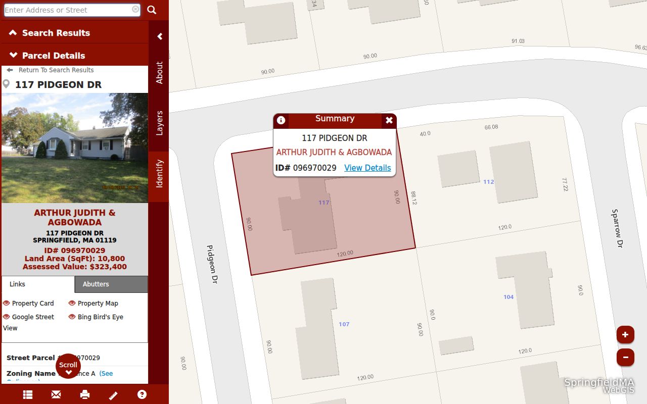
The map makes a parcel relationship visible. It does not identify every person who may use, visit, or occupy a building. Save the parcel ID and the map date before comparing any visible owner field with tax or deed records.
| GIS control | Type | Required | Block-use note |
|---|---|---|---|
| Enter Address or Street | Text with autocomplete | Optional | Select a suggested exact or closest match |
| Search icon or Enter | Button or key | Not applicable | Launches the address or street search |
| Parcel detail | Map selection | Optional | Select the parcel outline, then open details |
| View Details | Link or button | Optional | Opens the available parcel detail |
| Abutter distance | Dropdown | Optional | Adjacent, 100, 200, 300, 400, or 500 feet |
| Find Abutters | Button | Optional | Returns the selected-distance parcel set |
| Add or Remove Parcel | Buttons | Optional | Refines a subject set for corner or common-ownership context |
| Print Labels or Export List | Buttons | Optional | Produces the selected abutter set for record verification |
- Enter the address or street, accept the exact or closest GIS match, and select the correct outlined parcel.
- Choose View Details; note the subject PID, street address, and available property-card link.
- Use Find Abutters with Adjacent or a 100, 200, 300, 400, or 500-foot setting. Add or remove a parcel when a corner, condominium, or common-ownership tract needs clarification.
- Print or export the selected parcel set, then confirm ownership through the property card, tax record, and Registry deed rather than relying on one map label.
For a full named-street sequence rather than an immediate block, use the Springfield street directory and keep the parcel IDs as the bridge between addresses and property records.
Springfield Neighbors Across Map Layers
The GIS map provides context that a tax card cannot. Parcel outlines, building outlines, address numbers, lot numbers, parcel dimensions, street names, ZIP codes, neighborhoods, zoning, historic districts, election wards and precincts, community-policing sectors, wetlands, and common-ownership parcels can all be turned on separately. The aerial choices include 2025 imagery captured in March 2025 plus 2020 and 2013 layers. Use those layers to understand the map, not to turn a land record into a list of people.
Springfield recognizes 17 neighborhoods and 19 civic groups. Their edges are commonly described by roads, highways, parks, rail lines, and landmarks. That means the neighborhood, ZIP, police-sector, and ward labels at one address may not line up. Retaining the layer name with a research note prevents a later search from treating different local geographies as the same boundary.
Note: A parcel's ZIP label, police sector, and neighborhood label can each use different boundaries, so retain the map layer named with each result.
Springfield Neighbors and Voter Data
Voter information is not a map-browsing shortcut. Massachusetts' individual status route asks for first name, last name, date of birth, and the ZIP where a voter is qualified, then requires agreement to the form statement. It is meant to check a person's status, not to browse an address. A lawful local voter record can have different fields, but the statewide list is not a public record for unrestricted distribution.
A request for a Springfield municipal file belongs first with the Elections Office, the record custodian. Identify the year, municipality, precinct or ward, street-list category, format, and whether a complete municipal list or a particular record is sought. Research did not locate a City form, fixed fee, delivery format, or processing time for that request. Do not infer that an address record identifies all people at a parcel, and never use voter participation history to infer ballot choices.
Springfield Neighbors Through Civic Groups
The City Neighborhood Council Guidebook identifies 19 recognized groups. These are useful civic-contact leads when a parcel is tied to a neighborhood question. The guidebook and surfaced organization pages map public contacts, not the membership of a council or the people living in a district.
Armoury Quadrangle Civic Association
Public organization contact; no member list located. Historic core and Quadrangle civic lead.
Atwater Park Civic Association
Public contact-directory entry; no member list. Useful for address and community context.
Bay Area Neighborhood Council
Public group name and contact; no member list. A civic lead.
Concerned Citizens for Springfield
Public group contact; no member list. A neighborhood-history lead.
East Forest Park Civic Association
Public group name; exact public member directory not located. A civic lead.
East Springfield Neighborhood Council
Public contact entry. Useful for East Springfield block context.
Forest Park Civic Association
Public group name and contact. Useful for Forest Park context.
Hungry Hill Neighborhood Council
Public contact entry. Useful for the Hungry Hill and Atwater overlay.
Indian Orchard Citizens Council
Public contact entry. Useful for Indian Orchard context.
Lower Liberty Heights Neighborhood Council
Public contact entry. A block and community lead.
Maple High-Six Corners Neighborhood Council
Guidebook-listed recognized group. A neighborhood archive or civic lead.
McKnight Neighborhood Council
Guidebook-listed recognized group. A neighborhood archive or civic lead.
New North Citizens Council
Guidebook-listed recognized group. A neighborhood archive or civic lead.
Old Hill Neighborhood Council
Guidebook-listed recognized group. A neighborhood archive or civic lead.
Outer Belt Civic Association
Guidebook-listed recognized group. Useful for address-to-community context.
Pine Point Community Council
Guidebook-listed recognized group. Useful for address-to-community context.
Sixteen Acres Civic Association
Guidebook-listed recognized group. Useful for address-to-community context.
South End Citizens Council
Guidebook-listed recognized group. Useful for address-to-community context.
Upper Hill Residents Council
Guidebook-listed recognized group. Useful for address-to-community context.
Use a public organization contact only for its stated civic purpose. A contact point is not a private-address lead, and it does not identify the members of a council. The City allows recognized councils to update their organization contact information, which is another reason to confirm the current listing before relying on it.
Springfield Organization Address Checks
When a parcel owner field names a corporation, organization, trust, or other entity, preserve that distinction. The owner is not automatically an individual tied to the parcel. Massachusetts corporate search can be used to resolve a public entity name or filing number and to review filing-based roles and business-office information.
That form supports an entity-name search and individual first, middle, and last-name fields, plus identification and filing-number fields. A filing can show officers, managers, signatories, registered agents, and a business-office address. It is useful for checking an entity connection, but neither a registered-agent address nor a business-office line proves a person's residence.
Archives for a Springfield Block
For a historical community question, the Springfield City Library offers city directories, yearbooks, newspapers, an obituary database, and census access. Its local city-directory run spans 1866-1989. The Springfield History Library & Archives adds photographs, diaries, deeds, land records, personal papers, and local-organization material. Those collections can document a past connection to a street, school, association, or neighborhood.
Collection access is specific to the item. The reviewed sources did not identify complete public rosters for a congregation, block watch, civic club, or private group. A former classmate or community-history search can begin with an old directory, yearbook, newspaper, or obituary, but it should not become a claim about a present address.
Official Records or Commercial Neighbor Tools
Commercial neighbor-search products compile data from different sources. They can be useful only as a prompt to verify a record, because they can be stale, match the wrong name, or overstate a connection between a person and an address. The distinction below keeps the record custodian, date, and legal boundary in view.
| Question | Official record route | Commercial compilation category |
|---|---|---|
| Which parcel is next to the subject address? | GIS parcel outline and abutter selection | May combine address data without showing the parcel basis |
| Who holds title or receives the tax bill? | Tax record, property card, and Registry deed | May join dated or mismatched names and addresses |
| Can a public voter field be obtained? | Status route or a lawful local-office request | Cannot override protected-voter rules |
| How can an error be corrected? | Ask the record custodian about its record | Use the provider's own correction or opt-out process |
Official records also have limits: a map label can be dated, a deed establishes a recorded property connection, and a tax mailing line is not the same as a situs address. Verify a meaningful result with the custodian that created it.
Private Limits for Springfield Neighbors
Some address information must remain out of a block search. Non-owner occupants, household composition, utility customer data, motor-vehicle addresses, protected court and vital material, and restricted public-employee address data are not a public parcel roster. Massachusetts' Address Confidentiality Program supplies a substitute address and mail forwarding for qualifying people. Confidential voters are excluded from ordinary state database exposure, and G.L. c.66 §10B protects specified public-employee contact information.
The right response to a protected record is to stop, not to reconstruct it from other sources. A public-record request should describe the non-exempt record sought and go to its custodian under the Massachusetts Public Records Law. The statewide privacy framework also includes G.L. c.4 §7, c.66A, c.214 §1B, and other limits that apply to particular records and facts.
Lawful use. Use parcel and civic records for neighborhood context, reconnecting, or a property-history question. Never use a lookup to watch, contact, harass, or intimidate anyone; stop at protected data and request only non-exempt records from the custodian.